
Where
Not on the map yet.
Search for a place, or click the map, to drop the pin where the photo was taken. Street View follows the pin.
- Held by
- Montreal Holocaust Museum via Canadian Jewish Heritage Network (incl. Alex Dworkin Canadian Jewish Archives)
- Dates
- 1939-1945 (indexed as 1939–1945)
- Level
- item
- Extent
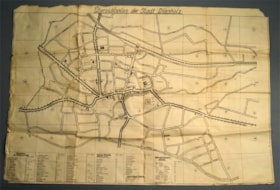
- Map : Paper : printed : Ink : beige, black ; Ht: 62 cm x W: 90,5 cm
- Scope & content
- 1 page. One-sided map of the city Diepholz. The document shows the main street of the town and was used by German soldiers to identify their surroundings. On the b. is a legend. Narrative: Henry Yall Fowler was a volunteer for the Canadian Military Engineers. He was posted in Netherlands and United Kingdom during the Second World War. During his service in Holland, he found this map in a German tank.
- Location
No place found in this description yet.
- Genre / form
- cartographic material
- In the picture
- BridgeCanalChurchCityDocumentMapMilitaryParkPrintedRailwayRailway CompanyRoadStreetStreet MapWarTagged automatically by a vision model; may contain mistakes.
- Text in the image
- Übersichtsplan der Stadt DienholzÜbersichtsplan der Stadt DiepholzRead automatically; may contain mistakes.
- Language
- German
- Harvested
- 2026-10-19T03:21:16Z · source datestamp n/a · andornot
Digital objects at the source
- imageOpen original at source ↗2015_02_02a.jpg
- imageOpen original at source ↗2015_02_02b.jpg